By Mirjam Ros-Tonen, Terry Sunderland, and Alida O’Connor
Unravelling stakeholder perspectives of landscape dynamics and trade-offs to understand and apply these is essential to implementing integrated landscape approaches (ILAs), according to recent training in participatory mapping in southern Zambia.
The CIFOR-based COLANDS initiative focused on participatory mapping during a training for trainers that included forestry officers, ward councillors, village headmen, NGO staff, and researchers in Livingstone, the capital of Zambia’s Kalomo district, 23 June 2022.
Participatory mapping promotes discussions on local communities’ terms instead of putting information onto “our framework,” said Terry Sunderland, professor of Tropical Forestry at the University of British Columbia (UBC) and CIFOR senior associate, who moderated the workshop.
“Participatory mapping gives local people a voice, empowers them by avoiding technical jargon they cannot understand, and the mapping process helps build the trust needed to discuss different visions, negotiate trade-offs between different land uses, and resolve conflicts,” said Sunderland, a team leader with the Collaborating to Operationalize Landscape Approaches for Nature, Development and Sustainability (COLANDS) initiative (Fig 1).

“It secures a balance between local stakeholders and outside experts while it generates insights into what each stakeholder considers important and how they see current landscape dynamics and future scenarios.”
Historical timelines
Workshop participants drew historical timelines to understand how past events affected the Kalomo landscape, including patterns and trends in agriculture, forestry, infrastructure, health, and education. This provides a starting point to discuss future scenarios.
Participants were divided into two groups (Fig. 2), and both started their timelines when colonial rulers declared Kalomo town to be the administrative capital of former North-West Rhodesia in
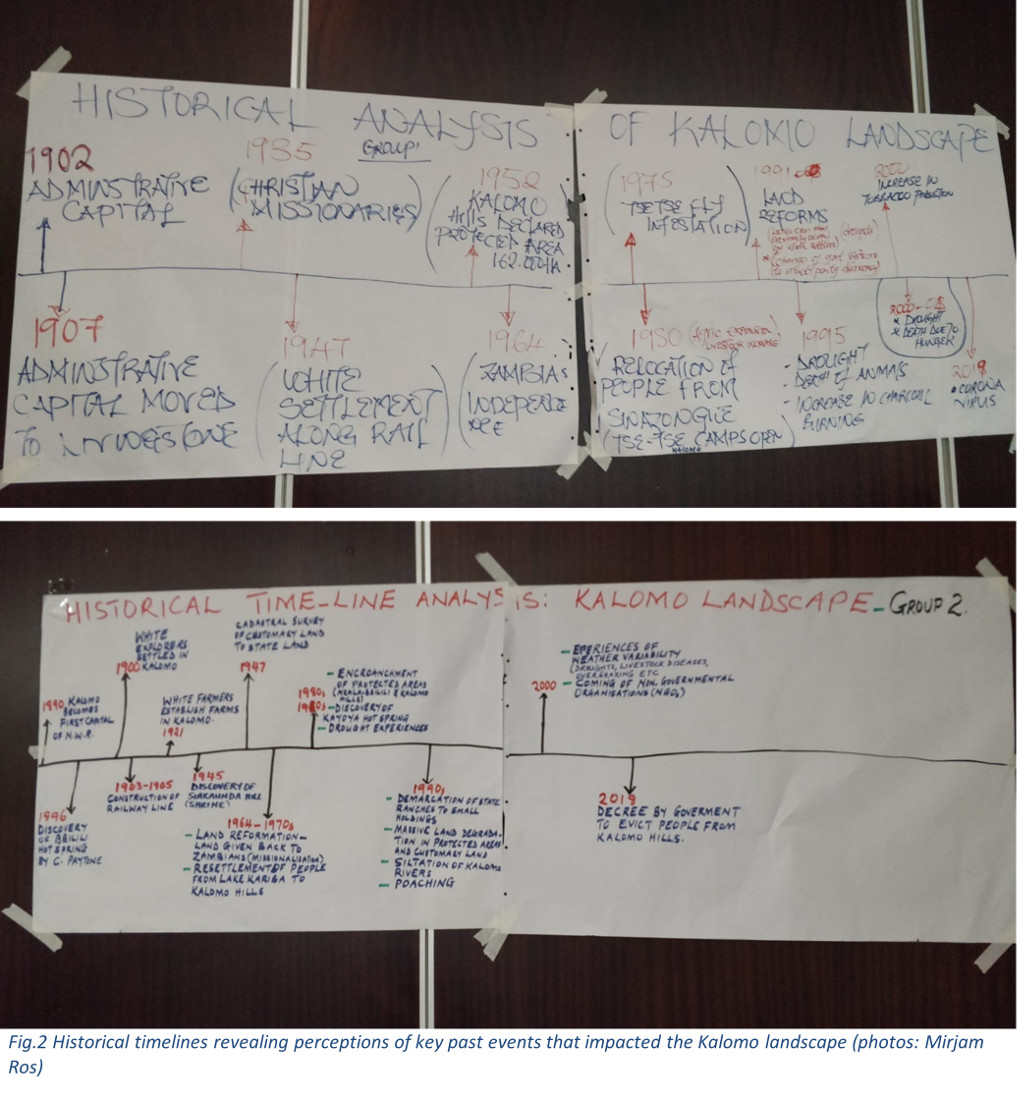
1902—a role it lost to Livingstone in 1907. Participants also marked the railway construction and later arrival of “white settlers” along the railway as a key impact on the landscape.

Each group then emphasised different events. One focused on natural disasters (Fig. 3) such as the tsetse fly infestations in the late 1970s and severe droughts in the 1990s, which both led to the death of people and animals. This group also pointed to the demarcation of Kalomo Hills as a protected area in 1952 and land reforms in the early 1990s, which changed people’s access to land.
The second group focused on laws and government initiatives that affected access to land, starting with the cadastral survey in 1947[1], which converted customary land to state land. In the decade following independence in 1964, the land was given back to the Zambians. The group marked the rule of the Movement for Multiparty Democracy (MMD) from 1991 (which lasted for two decades) as a period of land reforms involving state ranches and land taken by European settlers but were later devolved to smallholders.

Group two (Fig. 4) also focused on environmental problems created by humans and by climate change. Participants noted increasing poaching, overgrazing and encroachment of protected areas in the Najula and Bbilili wards and Kalomo Hills Forest Reserve in the 1980s and 1990s, leading to extensive land degradation. In 2018, the government signed a decree to evict people from the Kalomo Hills Forest Reserve. It has not yet been enacted.
Concerns over more frequent droughts, leading to river siltation and livestock disease, were raised by both groups as all have experienced increased weather variability and drought, particularly since 2000.
Maps of possible futures for Kalomo landscape
The two groups then mapped possible futures, where trade-offs are addressed, and livelihoods imagined – such scenarios are helpful as a management tool. Maps depicted different portions of the Kalomo landscape: Habulile (Nachibatula) village in the Chikanta Chiefdom and a part of the Siachitema Chiefdom where the Chief’s palace is located (Fig. 5).
Both maps clearly marked the boundaries with other chiefdoms, showing the importance of customary governance. The grazing areas on both maps revealed the importance of cattle in the region, and both also showed roads, water bodies, schools, and houses. But there was a remarkable difference in focus as well. The Habulile group meticulously mapped fields and crops, while the Siachitema group mapped places of cultural and ecological importance, such as the Kayoya hot spring, the Katanda Game Management Area, and the Chipondo forest.

Worst-case scenarios
A business-as-usual scenario for the future, including a worst-case scenario, was discussed: how the landscape would look in 25 years if trends continued and without interventions. Both groups depicted a similarly bleak picture, from loss of cultural values, beliefs and practices, to the disappearance of shrines and other sacred places leading to a loss of identity and heritage.
Population growth and climate change would result in silting and drying water bodies, land degradation and reduced grazing areas, leading to lower crop yields and livestock production. An increasing population will result in resource scarcity, increasing human-wildlife conflicts, and conflicts over land and resources, predicted participants. They also feared biodiversity loss and excessive heat due to loss of forest cover, exacerbated by climate change, increasing droughts, floods, and human and animal disease outbreaks (Fig. 6).

Gender perspectives on the future Kalomo landscape
When participants grouped by gender to discuss the landscape in the coming 25 years, it was quickly apparent that men and women view natural resources and their management differently and see different best-case scenarios for future prosperity and sustainability. Men strongly focused on outcomes, emphasising higher yields, healthy and increased livestock, preserved shrines that could be turned into tourism sites, fuller dams, flowing rivers, a green environment, and upheld cultural values, practices, and identity.
In contrast, the women discussed how to achieve best-case outcomes: harmonising policies, integrated land-use plans, building capacity and awareness among stakeholders of sustainable use and management of landscapes (Fig. 7). They emphasised the need to include minorities in decision-making and equal rights to access natural resources and land. Only after identifying the necessary steps, they discussed what the ideal future landscape should provide: free-flowing healthy rivers, diversified livelihood options, more diverse flora and fauna, and climate resilience – all leading to healthy people and livestock, less poverty, and increased agricultural productivity.

Negotiating trade-offs in a hypothetical landscape
Alida O’Connor, a PhD student at UBC, facilitated the last exercise. Participants were organised into stakeholder groups with various perspectives, interests, financial means, and power dynamics with the task of negotiating with others to achieve a theoretical landscape management plan. After the activity, participants discussed the challenges they faced, including the lengthy time it took to reach an agreement with the hypothetical provincial government and the fact that none of the stakeholder agreements included ongoing monitoring and evaluation of social and environmental impacts. Other key takeaways included stakeholders with opposing objectives avoiding one another and stakeholders making agreements that would impact communities without community input. Finally, participants reflected on the use of visual tools, such as participatory mapping to ensure diverse stakeholder perspectives are represented, as well as the importance of good facilitation to manage participants with conflicting perspectives and power imbalances (Fig. 8).

“The multi-stakeholder negotiation exercise does a great job of highlighting power differences between different stakeholders in a landscape,” said O’Connor. “For example, it shows who has the most bargaining power, or who must defer to other stakeholders to meet their objectives, and who is left out of these discussions.”
Next steps
Ideally, such participatory mapping exercises would now be undertaken in key communities in Kalomo. The outcome of the community mapping can be complemented by drone mapping to “ground truth” the community-derived maps and to match community perceptions of their landscape with the geographical reality. Both provide input to assessing desired future scenarios for planning and engagement with government and other stakeholders.
——-
Mirjam Ros-Tonen is an Associate Professor at the Governance and Inclusive Development programme group in the Department of Geography, Planning and International Development Studies, University of Amsterdam.
Terry Sunderland is a professor of Tropical Forestry at the University of British Columbia (UBC) and CIFOR senior associate.
Alida O’Connor is a PhD student at University of British Columbia (UBC).
Further reading
Asubonteng KO, Ros-Tonen MAF, Baud ISA, and Pfeffer K (2021). Envisioning the future of mosaic landscapes: Actor perceptions in a mixed cocoa/oil-palm area in Ghana. Environmental Management 68(5). https://doi.org/10.1007/s00267-020-01368-4
Best L, Fung-Loy K, Ilahibaks N et al. (2021). Toward inclusive landscape governance in contested landscapes: Exploring the contribution of participatory tools in the Upper Suriname River Basin. Environmental Management 68(5). https://doi.org/10.1007/s00267-021-01504-8
Boedhihartono, AK. (2012). Visualizing sustainable landscapes: Understanding and negotiating conservation and development trade-offs using visual techniques. Gland, Switzerland: IUCN. (56 pp). Available from https://sswm.info/sites/default/files/reference_attachments/IUCN%202012%20Visualizing%20Sustainable%20Landscapes.pdf.
Chambers R. (2006). Participatory mapping and geographic information systems: Whose map? Who is empowered and who disempowered? Who gains and who loses? The Electronic Journal of Information Systems in Developing Countries 25:1–11. https://doi.org/10.1002/j.1681-4835.2006.tb00163.x
Lucas FFB, De Vera DB, Marquez ND et al. (2018). A resource book on participatory geographic information system (PGIS) for land rights advocates. Volume 1 and 2. ANGOC and PAFID, Quezon City. https://landportal.org/es/node/101228 and https://landportal.org/es/node/101229
McCall MK. (2021) Participatory mapping and PGIS: Secerning facts and values, representation and representativity. International Journal of E-Planning Research 10:105–123. https://doi.org/10.4018/IJEPR.20210701.oa7
Ros-Tonen MAF, McCall MK, and Willemen LL. (2021). Spatial tools for integrated and inclusive landscape governance: Toward a new research agenda. Environmental Management 68(5). https://doi.org/10.1007/s00267-021-01547-x
Willemen L, Kozar R, Desalegn A, and Buck LE. (2014). Spatial planning and monitoring of landscape interventions: Maps to link people with their landscapes: A user’s guide. EcoAgriculture and Partners, Washington DC. https://ecoagriculture.org/wp-content/uploads/2014/11/SpatialPlanningGuide_10November2014.pdf
[1] Years mentioned in this article are those marked on the participants’ timelines and not necessarily accurate.
The material used in this workshop is based on Boedhihartono, Agni Klintuni. (2012). Visualizing sustainable landscapes: Understanding and negotiating conservation and development trade-offs using visual techniques. Gland, Switzerland: IUCN. (56 pp) https://sswm.info/sites/default/files/reference_attachments/IUCN%202012%20Visualizing%20Sustainable%20Landscapes.pdf.